29 January 2011
MC&G

(A Chinese view of the standard Mercator Projection of the earth with the Middle Kingdom….in the middle. Developed in 1569 as a navigation tool, it has always been a poor representation of the spherical earth. It constitutes the mental map of most westerners.)
Maps are really important, but they are fungible, you know?
We are seeing a revolution in the whole notion of what we used to call “Maps, Charts and Geodecy,” or MC&G or short. We don’t even blink at GPS-enabled talking devices in our smart phones, or cameras that collect precise geolocations for our snapshots. The applications are burgeoning, and we don’t even necessarily know about them.
Some are useful. I saw a great interactive chart this morning that outlined the locations and progression of the demonstrations in Cairo that may bring down the Mubarak regime. That event could change the lines on the maps of the Middle East.
They change periodically and it is hard to keep up. Years ago, we hosted some Israeli pilots on the good ship Forrestal during a port visit to Haifa years ago, and naturally we had a lot of maps of the region prominently posted, updated with the latest change information from the Defense Mapping Agency. I was quite proud of that, since the aircrews often thought that our vast stock of charts, available for them to cut up to make kneeboard nav charts, represented ground truth, rather than a snap-shot in time when they went to press in the plant in St. Louis.

(My view of the State of Israel, in white, circa 1990)
The Israelis needled us about why the West Bank was demarcated from the Jewish State, as though it had not been thoroughly conquered and then occupied. I shrugged in embarrassment, and said it was a St. Louis thing where the maps were printed. Maybe old stock, I said.

(An Israeli view of their state, circa yesterday.)
I thought it was fungible. By that, I thought the whole notion of place is interchangeable, morphing at the action of humans right beneath our sneakers.
The institutions that make maps are fungible, too, both in time and space. It starts with the great explorers who drew those crazy skewed charts from their personal experience to the astonishing towers of information that Google puts out, fusing overhead imagery with the human artificiality of streets and political boundaries and businesses.
Before there was business in the map game there was the government, of course, and is the root of it all, for the purposes of establishing sovereignty, property rights, commerce and military operations. Some of the best maps come from the artillery surveys of previous eras; nautical and aviation charts are necessary for all manners of activity.
What constitutes a map, and what constitutes its validity is something that can be quite emotional. It came to me suddenly this week when I got a note from a pal about a stern protest by Vietnam’s foreign ministry about something the Chinese had done.
The industrious PRC has apparently created a website called “Map World that “seriously infringes” Vietnam’s territorial claims over Paracel and Spratly Islands. China is of the opinion that they belong to them, and constitute one of the island barriers that are the “String of Pearls” of critical national security.
China’s State Bureau of Surveying and Mapping is challenging the dominance of Google Earth and other private sector map providers to ensure that the government has more control over an industry it regards as a matter of national defense.
The map includes a line of nine dots demarcating a baseline by which the entire South China Sea belongs to China.
You can check it out yourself at http://www.tianditu.cn, but here is the story:
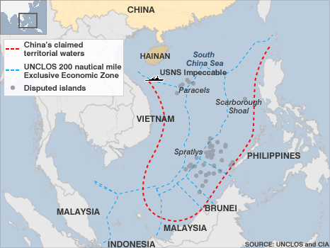
(Chinese territorial claims in the South China Sea at the time of the USNS Impeccable incident in March of 2009. UNLCOS= UN Convention of the Law of the Sea. Source: CIA Fact Book.)
“Viet Nam calls on Map World to rectify East Sea line error
HA NOi — Viet Nam has protested against information provided by China on January 18 to the Map World service, in which the nine-segment claim line on the East Sea continued to be present, and asked China to remove the incorrect data immediately.
"The Chinese State Bureau of Surveying and Mapping's official provision of the ‘Map World' online service in which the nine-segment claim line on the East Sea is present violates Viet Nam's sovereignty over the Hoang Sa(Paracel) and Truong Sa (Spratly) archipelagos," said Nguyen Phuong Nga, the spokesperson for the Foreign Ministry, in response to reporters' questions on Viet Nam's reaction.
The act also violated sovereign rights and jurisdiction rights over the exclusive economic zone and continental shelf of Viet Nam and East Sea-rim countries, and completely ran counter to regulations of the 1982 UN Convention on the Law of the Sea and the spirit of the Declaration on the Conduct of Parties in the East Sea, she said yesterday.
"Viet Nam protests China's action and asks China to immediately remove incorrect information on the above-mentioned map," she said. — Vietnam NS
It brought back some lessons-learned rom long ago.
I had the opportunity to be in Saigon on the 30th of April, 1995, on the anniversary of the fall of the city to the Communist North. Congressman Bill Richardson made me give a brief address of congratulations to the Mayor of the renamed Ho Chi Minh City, the son of a gun.
I was one of the dozens of official Americans who were in the SRV that summer.
The week before we had been Up North, in Hanoi. The ostensible point of the visit was the POW-MIA issue, which for years had been the only point of mutual interest between the Communists and the various administrations in Washington.
The US and Vietnam conduct first joint field investigations on MIAs in 1988, shortly before SRV forces pulled out of Cambodia. The experiment went well enough that the Vietnamese, seeking to end the trade embargo that had been in place since the fall of the south, permitted the establishment of a US liaison office in Hanoi in April of 1991.
That office eventually became the JTF-Full Accounting and eventually Det 2 of the Joint POW-MIA Accounting Command (JPAC). The official history claims JTF-FA was established in 1997, but that is what the office was called when we were there in '95, not that I would claim the command history is wrong.
The office was the key pivot point in bilateral relations. The POW recovery efforts were part of a two-phase diplomatic initiative, with the office serving as the de facto direct contact with the SRV government. Things were perking along- in December 1991, Washington lifted the travel ban- and in 1992 began to ease the embargo. Along with that incremental step, Retired General John Vessey was dispatched to Hanoi as a special U.S. presidential envoy on MIA issue. In all, the former CJC made six trips and coordinated the way ahead for cooperation on recovery issues, and incidentally, a framework for larger cooperation.
You may recall that Mr. Bill ran a sort of unofficial state department. He had been a staffer on the House Foreign Affairs committee and had a flair for adventure and a little not-so-vicarious danger when he was elected to the House himself. He used his seat on the HPSCI to get DoD to pick up the tab on his CoDels, which is how I got involved with him. My portfolio in navy's Office of Legislative Affairs was to lobby (likewise unofficial, of course, the Executive branch cannot lobby the Congress) the Committee on matters of interest to the DNI, which was more than a little bit dicey since I was supposed to be working for Big Navy.
It was interesting.
Anyway, Bush I signed an executive order permitting U.S. companies open offices, sign contracts and do feasibility studies in Vietnam in late 1992, and when Bill Clinton took office the pressure to normalize relations intensified. He settled the matter of Vietnam's $140 million arrears to the IMF, which opened up international lending, and in further eased sanctions to permit American companies to bid on development funds provided by the World Bank.
By early 1994, CINCPAC Chuck Larson made an official visit, centered on JTF-FA, and he reported that ending the sanctions completely would provide the best way to gain access to MIA sites across the SRV. As you recall, the mass hallucination of Rambos let behind in the jungle behind was fading.
It is still emotional.
There may have been hold-backs in Laos or deep in the south. There was a curious “Duty Station and Whereabouts Unknown” (DUSTWUN) file in the open case milk-crate at the Bureau when I stood the weekend duty at the Navy Annex. It contained the Central Identification Lab report of remains of a navy pilot who was shot down shortly before the Paris Peace Accords were signed. The bones had been returned by the Vietnamese, and were scorched, but the report indicated the femurs had "well healed" fractures that were obviously not broken when he went flying from the carrier, and which would have taken years to mend.
So, his widow smelled a rat and would not accept the remains until someone explained where he had been after the POWs came home and the fractures had time to heal. For that matter, I am still not convinced that our missing Naval Intelligence Officer Jack Graf was not transferred to the Soviet Union along with some of the guys held in Laos.
Others disagree. But those visceral emotions were fading for the public at large and the time was about right for something to break.
In 1994 the Senate passed a non-binding resolution (championed by odd couple John McCain and John Kerry) urging Mr. Clinton to end the embargo on the grounds that it would permit complete access to recovery operations. He did, and it did, though the Vietnamese continued to dangle opportunities.
The access issue was real enough, but like I said, this was at least a two-track operation, since the Congress was still a little nervous about the whole thing, and they had passed another somewhat contradictory resolution telling the Administration to keep its eye on the MIA issue as the first priority.
So it was still a sensitive issue, and that was what was attractive to Bill Richardson. I saw him in the Senate Hart Building in the early Spring of 1995. We had traveled to Haiti, GITMO and the DomRep the fall before and the trips went well. He brightened and outlined a scheme to go to Taiwan, Burma, Thailand, Hong Kong, the PRC and North and South Korea to discuss a variety of issues.
Ang San Suu Chi's house arrest and Karen refugees were the topics with the SLORC, and elsewhere in the region the POW-MIA issue was the hook for getting the attention of the rogue regimes.
I can say with some certainty that none of them gave a shit, with the exception of Vietnam. They had agreed to return the former US Embassy in Saigon (it had been the home of their oil ministry for a while) and it was pretty emotional to visit the iconic building, not as a tourist but as a returning owner.
Which is a long way around the rose bush to get to the importance of Maps, Charts and Geodesy.
Back in the day, the Defense Mapping Agency was the de facto arbiter of the world's lines of demarcation. When we sat with the President of Vietnam and asked him what we could do for him, he said, through the earnest young translator, "Change the little box on the map."
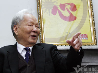
(President Le Duc Anh of Vietnam. Photo courtesy Vietnam.net.)
We looked at kindly old Le Duc Ahn in amazement, and it took a couple exchanges to get at what he was talking about. As it turned out, there was a NOTAM affixed to the DMA charts that indicated the Air Defense Identification Zone (ADIZ) was a hazard to navigation. The President pointed out that international insurance carriers used the chart notation as justification for charging steep premiums for what were now thoroughly routine peacetime flights.
Among a thick portfolio of issues he had encountered, Bill took that back to Mr. Clinton, and the box was deleted from the next edition of the air navigation charts.
I am not saying that our visit was the key, but it was the opportunity to reiterate to our President that Vietnam was "open for business" again. A couple weeks after we left, the SRV turned over 100 pages of maps and reports about U.S. servicemen killed or captured during the war.
We reciprocated. In response to the only somewhat-ironic comment from their foreign ministry that American help in locating the million missing Vietnamese would be useful, a US veteran's map helped locate a mass grave of Viet Cong cadre killed during the war.
Secretary of State Warren Christopher formulated the plan, and on July 11, 1995, President Clinton announces normalization of relations with Vietnam, saying "the time has come to move forward and bind up the wounds from the war."
My little part in all that was a text-box on a map. It is no surprise to me that the Vietnamese take the Chinese maps so seriously, and is it a mark of the rise of China that they are concerned it will have the same sort of impact on the wide world that the ones from St. Louis used to.
It is purely fungible. And really important.
Copyright 2011 Vic Socotra
vicsocotra.com | Subscribe to the RSS feed!