
(High resolution photo by Stephen Powers, 2015.)
If you are going to go look at some of the Stones and get a decent sample, I have a recommendation for you. Do the ones of the Southwest Quadrant. Most of them do not have stories with a lot of depth to them. They just are what they are, but some have taken some real abuse over the years, and one stone (SW2) is an out and out fraud.
It is an outrage. But I digress.
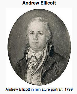
Approximately 100 years after Andrew Ellicott’s team finished the survey of the District’s original boundary line, area residents began taking an interest in the Stones as a link to the earliest days of the Republic. I mention Marcus Baker, the first guy who wanted to see them all and assess their condition.
Marcus began his version of Stone lunacy in June of 1894, and was quoted as saying that he has spent “many delightful hours between four o’clock and sundown” walking the route. He published his observations in the annals of the Columbia Historical Society, and was the first advocate for an effort to reserve what he found. He wrote:
“…inspection must be made from time to time and the inspection must be in turn followed by repairs and renewal when necessary if permanency is to be secured. The results of the inspection here described make plain the need of renewal in some cases and of repairs in others. The closing years of the century seem an opportune time to draw the attention of the proper authorities to the matter with a view to having this work done.”
No one seemed willing to take up the burden, though he served as inspiration for the next man to get interested, the archeologist with a theatrical flair, Fred E. Woodward, who took along his camera.
You can follow his path by car or bike, or even on foot, though that is going to be a pretty good hike to do the whole quadrant at one go. SW is easy. It is the way Ellicott and his party did it- Northwest from the South Stone to West, then Northeast to North, SE to East, and finally Southwest to South. It is safe and sane all along the border between Fairfax and Arlington Counties and the Stones, despite their periodic migrations, are never much more than a mile apart- that was the whole point.
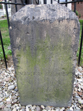
There are plenty of places to eat and drink in the SW quadrant, which also makes the SW leg a joy. If we started at the Jones Point Lighthouse in Alexandria at the South Stone, walk back out to the parking lot and head west on Jones Point Drive for about a third of a mile, taking a right turn onto South Royal Street for another third, then a left onto Gibbon and a final right turn onto S. Payne street. SW1 will be on the right, across from the old cemetery in the yard of the house at 1220 Wilkes Street. You will see the distinctive cage commissioned by the Daughters of the American Revolution- and a well-preserved Stone.
Look carefully. For should you get hooked on this journey, sometimes it is only the signature of the cage that will help you identify some of the more bedraggled stones and in the thick underbrush of Virginia or the District’s wilder areas. This is a good year for the attempt, by the way. Many of the Stones have had some sprucing up by volunteers in honor of the centennial of DAR’s attempt to preserve the first monuments of the United States.
You will feel an immediate sense of accomplishment at your feat of navigation and historical investigation. You might want to drive on to the Union Street Public House to celebrate. That would not have been possible for Fred Woodward.
Like Baker, he found that SW1 stood behind the house of one Oscar Baggett. Baker had described it “slightly seamed,” but by Woodward’s expedition in 1906 the Stone had been dug up from it’s place in the Baggett family garden and unceremoniously deposited on its side 225 feet away. It lay by a high picket fence at the edge of the-then open field adjoining the Baggett property line.
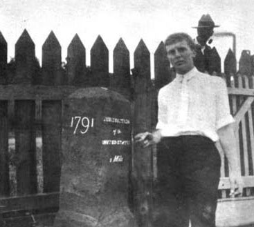
The industrious Woodward was hot on the trail, and had burly workmen raise it upright so he could photograph all the sides and footing. This was the first time since Ellicott’s party had placed it that an entire Stone was visible. Writing for the Columbia Historical Society, he noted that:
“From this picture one gets an accurate idea of the original shape and size of the milestones, the lower half being left rough as it was quarried, while the remaining part of the stone was accurately sawed one foot square, the top being beveled for four inches.”
SW1 was later re-set into the earth, upright and proud, but the diggers did not align it properly. In its current manifestation, it is facing in the wrong direction, a quarter turn from the original orientation. The side announcing “Jurisdiction of Virginia” actually faces in toward what was (until the 1846 retrocession) the “Jurisdiction of the United States.”
There is some high drama on SW1. Fred noted the size of the letters on the side of the stone facing the Federal Enclave (it wasn’t the District yet) were of a different size and script than all of the other stones. Subsequent enthusiasts like Edwin Nye surmises that the smaller, shallower, and less artistic script visible on SW1 indicates that it was carved by a different stonecutter than the rest of the boundary markers. Nye believes that Ellicott’s team might have been unhappy with the work of the original stonecutter and replaced him with another vendor to complete the next 38 Stones.
Woodward’s survey included the first photographic images of the Stones. While Marcus Baker’s work was authoritative, but was dry prose. Woodward made the Stones the rock-stars of their day, so to speak. The increased interest by the public at large led to concern that the Stones were at risk to plow, construction and general deterioration.
Woodward recommended that each be surrounded by an iron fence “four or five feet square” so that these monuments would be preserved “for the benefit of those who come after us.”
Woodward’s advocacy prompted local chapters of the to adopt one or more of them and then assume stewardship. As part of that effort, the chapters made arrangements with a local iron-monger in late 1915 to produce a standard and uniform set of iron fences “about 3 feet by 3 feet in size and 5 feet high” to be placed around each stone.
A century ago that cost $18 bucks a pop, though in constant-dollars measuring real value, it would set you back about $895 in 2016 greenbacks per cage.
So, there you have it: SW1. If you are feeling up to it, we will go look at that bogus SW2. Or, we could stop at the Union Street Pub and take a break. We have already gone more than a mile!
Copyright 2015 Vic Socotra
www.vicsocotra.com
Twitter: @jayare303