
If there is one of the cardinal Stones to see, this is the easiest and safest in the City. There is nothing particularly dangerous about Jones Point, and thee South Site, but it is hard to imagine 100 square miles of the original District of Columbia pressing down at you with a point that would crush you like a bug.
The North Cardinal Stone is in the middle of a traffic circle, so you could get hit by a car trying to get to take the photos that prove you were actually there, and most of the drivers are from Maryland, after all. The East Stone? When I was there to find it, the scene was spooky. There were once-nice row houses scorched by flames and boarded up. The whole thing made you jumpy- which is why this prime story of America’s first monuments has a dark edge to it, one of actual real palpable physical danger.
Or at least it did. The West stone is in a park in Falls Church named for Major Andrew Ellicott. I mentioned that he has a city named for him, as well, but I have to credit that attribution to the family, rather than Andrew himself. He was a big, energetic man, bluff in countenance. He and the much shorter and rotund Benjamin Banneker must have made a remarkable pair as they road down to the mouth of Hunting Creek at the beginning of 1791.
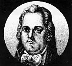
But Ellicott could have had much more, even his own Metro Stop. Everyone credits Pierre L’Enfant with platting the strange pattern of rectangular streets and diagonal boulevards that make the nation’s Capital so quirky. But it turned out that politics and rivalries drove the Frenchman out of town, and it was Major Ellicott, done with his marking of the Federal Enclave in 1792, to actually complete the city’s design.
So really, it should be the Ellicott Plaza Metro stop. But that is the way of history. The Major, like me, was eager to get out of town. He considered the politics to be too toxic, and remember, this was at the beginning of the Constitutional Republic, and barely had the wrappings off.
On Interstate 66 there is a little marker where you cross the line between Arlington and the original District and Fairfax County. I mention that because I had seen the sign hundreds of times without realizing that the Western Boundary Stone was- literally- a stone’s throw away.
Today Falls Church is a pretty plush place to live. Many of the older homes are modest enough, but nearly all will set you back the better part of a million bucks these days, and some of the newer, fancy ones a lot more. But in the days when the stones were still new, Falls Church was like many other colonial Virginia settlements. It had begun as a “neighborhood” of large land grant plantations anchored by the Glebe House and chapel of the Anglican Church. By the time the Major’s work crew had hacked their way northwest from Jones Point, the large land holdings had been sub-divided into smaller farms, many of them relying on enslaved labor.
With the soil exhausted by tobacco, new crops including wheat, corn, potatoes, and fruit were grown for area markets. At the same time, the prospective movement of the US Capital from Philadelphia to Washington, D.C., brought a gradual influx of workers to nearby Falls Church.
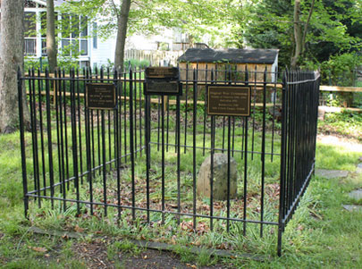
Taverns also opened to serve travelers going to and from the federal district. Trust me, every generation of Federal workers since has been appreciative of that fact. Anyway, visiting the park is easy, safe and fun. You can stand outside the protective cage (this Cardinal Stone is a square cage, not the circular ones at the North and East) and actually see how the Major’s scheme worked, the right angle stretching out for ten miles southeast to the Potomac, and northeast across the mighty brown river and to the apex of the diamond.
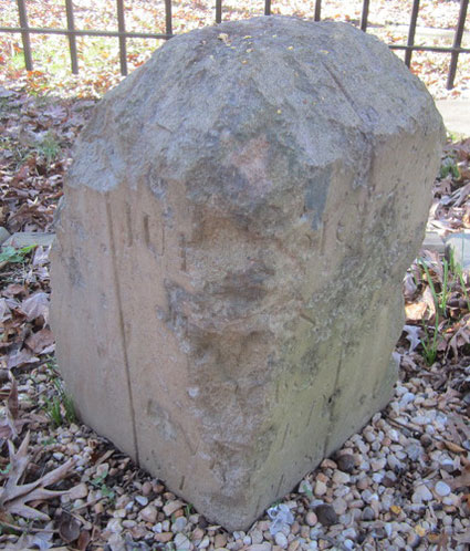
Some call the West Boundary Stone the “Ellicott Stone,” and I guess that is OK if the Major cannot have a Metro stop. It is located in Ellicott Park: 2824 N. Arizona Street (sometimes listed as 2824 Meridian Street), south of West Street in Falls Church, Virginia. It creates the boundary line of Falls Church City, Fairfax County, and Arlington County. Originally under the care of the Virginia DAR, the obligation was switched to the Falls Church Chapter and dedication took place in 1952.
In 2012, most of us were in bed when a massive, violent storm known as a “derecho” swept through with an instant wind-shock of as much as a hundred miles an hour. It nearly ripped the balcony door off my condo, and in addition to widespread devastation across the Capital, it caused a massive oak tree limb weighing several hundred pounds to fall on the Ellicott Stone. Fortunately, the iron fence surrounding the stone took the brunt of the impact force of the fall, so the stone was undamaged. The Falls Church Chapter enlisted the help of the Boy Scouts in sponsoring an Eagle Scout project to repair the damage to the cage, and I must say, the boys did a nice job.
If you are going to do this in sequence, and you can do all the Virginia Stones in an afternoon, start from the “Banneker Stone” at 1801 North Van Buren Street. Head north on Van Buren toward 19th Street and turn left on the first cross street to get to it. 19th St veers slightly right and becomes N Westmoreland St. Follow it two tenths of a mile and turn right onto Rt-29, the Lee Highway, for just a quick jog since you will go left at the first cross street onto 25th St. Use any lane to stay right onto Fairfax Dribe, and continue onto Lincoln Avenue.
Turn right onto Meridian Street and park in the lot that serves the quarter acre park. The West Stone will be on the left.
You are going to like this one, I think. I know I did. Tomorrow, we strike out to the northwest, into the wilds of North Arlington, and the rich folks who live there.
Copyright 2015 Vic Socotra
www.vicsocotra.com
Twitter: @jayare303