
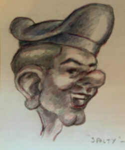
(This caricature of a sailor named “Salty” was found in the piles of paper shipped from The Farm to Arlington. It was drawn in 1945, and we are 99% sure of the year. We also believe he has been 99.71% of the way around the world).
We are not confused this morning. We are addled. That word refers to several moments yesterday. We talked about what may be to come when Congress returns to DC this coming week. But instead we wound up looking at old pictures. The one above is labeled “Salty.” He looks like that. It was sketched by an aspiring industrial designer who happens to be one of the fathers of those currently in the Writer’s section.
We had never seen that image. It had been saved in an old sketchbook that had been sent to the Navy’s flight school in 1945. We remember that year as the one in which the Bombs were dropped on Japan and ended the largest struggle in human history. The Navy could not count on that being the result of something dramatic, so they continued to train new aviation specialists to conduct the invasion of the Home Islands.
That did not happen. Just weeks after the Surrender on the decks of the USS Missouri, the Wings of Gold were awarded to the young men in that training class and they were released to “Reserve Service.” One of those big social changes was already in progress with the return of Peace. The Artist was back in New York City, courting a lovely young woman who had left her home by the Big River in SE Ohio to support the war effort by working for the Texaco Corporation in their 14-floor complex in the iconic Chrysler Building in Mid-town New York.
Reading some of the notes about that was amazing. Which brought up several aspects about the lives of the millions of young men and women who did their bit to secure victory in the historic struggle. “Salty” was the product of one of them, which led us this morning to a matter some of the Old Salts had previously considered. Some of us had served on USS Midway, a large ship forward-deployed to Japan in the 1970s to respond quickly to events Washington deemed important. In the course of that assignment, Ma Midway visited Mombasa, Kenya, on the way to responding to the 1979 Iranian hostage-taking at the US Embassy in Tehran.
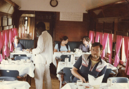
(This is the Night Train to Nairobi, Kenya at breakfast time. You can see mount Kilimanjaro around that time).
This is the view from the dining car of the Night Train to Nairobi. The topic here is ‘breakfast,’ and it led directly to a vigorous discussion about how far West the Capital of Kenya might be on the Meridian of Longitude. The question was actually not about the quality of the food, or the Tsavo East Game Park through which the train tracks rode. The more direct point was that nonsense about world travelers, and whether any of us had actually been around it. The discussion ranged from those who had gone west from California to Japan, and from there south and west to the Indian Ocean. After a stop in Australia there was word of the crisis in Tehran, and the ship headed north to provide presence in case Washington directed action against Iran. There was a scheduled stop in East Africa, and to the surprise of the participants, the ship was directed to make the stop in Mombasa while people were directed to get ready in America in case they were needed far away.
So, there is that story from the Salts, and then the question. Who had deployed west and east? Several hands went up. The deployments ‘East’ from the Continental US (CONUS) normally went to the Mediterranean Sea. It was a hot topic, since we just published the book titled “Last Cruise of the Cold War.” The question was simple but disorienting. To the best of our recollection, the lonely hill-top stronghold of Masada is as far ‘east’ as anyone had deployed. If that Longitude was east of Nairobi in Kenya, we had been all the way around the world, east and west.
That meant searching for lat-longs, the “latitude and longitude” way we used to find ourselves on the road while in travel. Nairobi, Kenya, is published as being at 1.28 degrees South, 36.81 East. Masada is located at 31.3 North, 35.35 East. Had any of us actually been “all the way around?” We decided some of us had. But as someone’s father noted, that would require tags on the luggage:
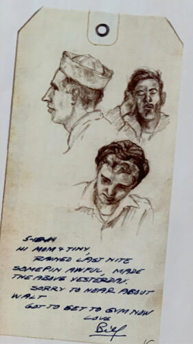
We don’t know what happened to Walt, or better said, who that might have been in 1945. But we think the tag might be as useful as the lat-long coordinates. And the joy at the idea that something had been accomplished between west and east voyages.
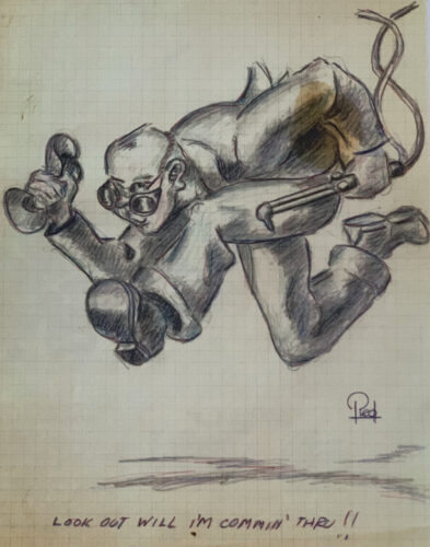
And that fellow with the nick-name ‘Salty’ could therefore claim to have accomplished whatever he needed for “all the way.” We think he might be a few miles short. The earth is 24,901 statute miles around at the equator. We would have to do some math to see whether the north-and-south difference makes the east-and-west match up. We used to think we were a little more than 79 miles short. On the upside, our Economist Buck claims that Salty had actually been 99.72% of the way around, which we agree is “close enough for Government work.” But for those in a hurry to make it all the way, we found another 76-year-old sketch that demonstrates a certain urgency across the years:
Copyright 2022 Vic Socotra
www.vicsocotra.com