
The South Stone
Gentle Readers, I warned you I was going to get back to this. Stand by for Stones!
“May this stone long commemorate the Goodness of God, in those uncommon events which have given America a place among nations. Under this stone may jealousy and selfishness be buried forever. From this stone may a superstructure arise whose glory, whose magnificence, whose stability, unequalled hitherto, shall astonish the world and invite even the savage of the wilderness to a shelter under its roof.”
-Rev. James Muir, at the dedication of the South Stone. George Washington was not there, though he visited the next month to pay homage.
We always tried to make visiting the Stones and adventure. It was erratic. In the summer and fall of 2002, we were at war, but it was a strange one. I was still on active duty, recently separated from my wife of nearly twenty years and with a knot of anxiety that went along with the attack on New York and the Pentagon. The Stones project seemed like a harmless way to blow off some steam, and naturally, I started with the easiest ones to find. It seemed logical to start with the first, which was the South Stone. But it was always one of the easy ones. Let me tell you about it.
The southwest quadrant of the old District is close, and it was there that I started the quest. I think I had some people with me, probably some of the usual pranksters, and we drove down to the park at the Jones Point Lighthouse. The place is a pleasant area of green in the bustle of the Old Town hipster community and the posh gentrified town homes, but in the day when Major Ellicott selected the place for the South Stone, the one that would determine the orientation of the Federal Jurisdiction, it bustled with commerce, docks and ships coming and going near the highest point of navigation of the mighty Potomac.
The old Wilson Bridge towers above the park. It was widely known that that the constantly increased traffic load on the bridge was shaking it to pieces. Walking toward the green open space, you could hear the banging as wheels hit the expansion joints and periodically object would fall from the deck high above. It was strange to see the structure fro this perspective, and of course there was a minor war in progress between the NIMBYs who did not want it replaced, since it would be inconvenient for years during construction.
It was more inconvenient, of course, to have a wheel ripped off your car when the concrete collapsed, as it sometimes did to hapless commuters.
There had been a massive shipyard constructed at Jones Point to build ships for the Great War in 1918, which obscured the Fresnel lens of the old lighthouse, and the structure was deeded to the Mount Vernon Chapter of the Daughters of the American Revolution (DAR), an organization that features prominently in the saga of the District Boundary Stones.
The ladies of the DAR maintained the structure as a museum until 1936, when the Army built a classified communication facility on the former shipyard and closed it to the public. When it re-opened to public use, visitors found that erosion had forced the Army to erect a seawall to protect the lighthouse from washing away in one of the Potomac’s periodic floods.
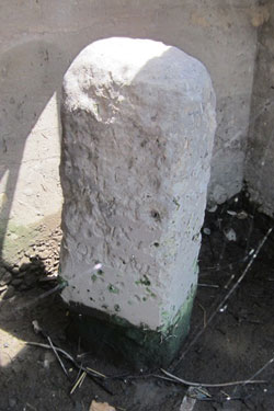
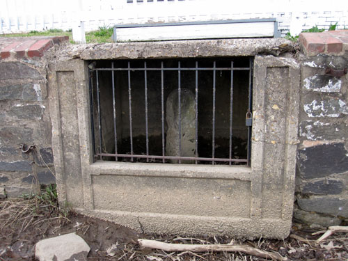
The Stone itself is just where Ellicott and Banneker left it, though it is now contained in a seawall, wherein lies a story.
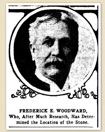
There is a padlocked steel gate to protect it, and because the stone remains in an enclosure in the wall, it can be difficult to view it in its entirety. That is an improvement, though. The first real attempt to identify where the Stones were located goes back to an eccentric historical enthusiast named Fred E. Woodward, who undertook a journey of exploration in 1899 to find them all.
He was far crazier than I am, but it is to him, and to one of the early cartographers of the District, Mr. Marcus Baker who did the preliminary research to find the Stones on which the odyssey is based. The South Stone was one of the ones that was missing, and that is particularly significant in view of its specific significance in the orientation of all the others.
That was known at the time of its placement. The party that placed the first Stone was composed of the Master of Masonic Lodge 22, Dr. David Stuart, the Town Sergeant, Mayor of Alexandria, Surveyor Ellicott, a Recorder, and “such of the aldermen and common council as were not Freemasons,” followed by a line of citizens, two by two.
When Mr. Ellicott had ascertained the precise point from which the first line of the District was to proceed, the Master of the Lodge and Dr. Stuart, assisted by others of the brethren, placed the stone, after which a deposit of corn, wine and oil was made upon it.
The company partook of some liquid refreshment at the site, and then retired to the place from which they came, where a number of additional toasts were proposed and drunk.
In 1855, the United States Government built the lighthouse at Jones Point for the safety of navigation on the Potomac. It featured a light with a Fresnel lens that could be seen for nine miles. The South Stone was about 15 feet south of the lighthouse.
Six years later, due to the continued scrub of the relentless river, the Corps of Engineers constructed a retaining seawall “upon the top of, and over the stone, completely hiding it from view.”
Woodward said it dramatically in his address to the Historical Society: “For more than half a century, no human eye has looked upon this earliest monument.”
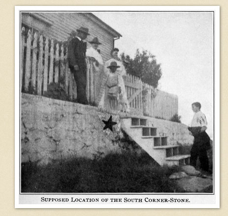
“About eight years ago, I visited the site of each of these ancient landmarks and was able to secure photographs of nearly all of them. The result of these excursions a paper I called “A Ramble Along the Boundary Stones of the District of Columbia.” At this time and, in fact, ever since the Civil War, the exact location of this stone has been a baffling mystery, though there has been no uncertainty as to the main fact, which is that the stone was somewhere under the sea wall of the Jones ‘s Point lighthouse, below Alexandria.”
“In 1894, Marcus Baker said in his “Surveys and Maps of the District of Columbia,” that ”On the 15th of April, 1791, there was laid with solemn and elaborate Masonic ceremonies, the corner stone of the District of Columbia. This stone, still standing, though hidden f rom view, forms a part of the foundation wall of the lighthouse at Jones Point, near Alexandria. It is under the gateway in front of the south door of the lighthouse.”
“The lighthouse keeper, Mr. Greenwood, may have been the last person to see the stone at the time the wall was built.”
Woodward continued: “A year or two ago the flight of wooden steps referred to was washed away by a severe storm, leaving this portion of the wall immediately accessible, as it had not been before. Mr. E. B. Gregg, of this city, rendered a very acceptable service by discovering on the face of this wall, an arrowhead mark, evidently made for a purpose. The discovery of this mark, which agreed so nearly with Mr. Sinclair’s description, seemed conclusive to me that the long-looked-for stone bad been definitely located, if not discovered, and immediately took steps to secure the necessary authority to demolish a part of the wall, and bring once more to light this ancient landmark, this first tangible mark of an effort to implant in what was then a wilderness, the permanent boundaries of the future home of the infant republic.”
“In today’s light, and in the prophetic light of the future, what momentous events radiate from this bit of sandstone. Both branches of the United States Government having charge of the reservation, the Engineer Corps and the Lighthouse Board, readily gave their permission, but stipulated that there should be no expense attending the same, chargeable to their department, and that everything should be done under their direction.”
The Corps of Engineers dug under the arrowhead, and sure enough what emerged was the South Stone, only inches from where it was supposed to be.
As Fred noted in 1913, “The stone is slightly varied in shape from the remaining ones, being about eleven inches by nearly fourteen inches, instead of the usual twelve by twelve.” The Washington Times reported that “The inscriptions are almost illegible, only portions of the letters being visible, these being on the southwest side, the southeast side bears a part of the date, the figure ‘7’ being discernible. … The two remaining sides are unmarked and bear no evidence of ever having been inscribed.”
That is the story of the South Stone, which was lost, and now is found. It is also a fine place to raise a toast to the future of a young Republic. Just don’t let the Park Police catch you.
Copyright 2015 Vic Socotra
www.vicsocotra.com
Twitter: @jayare303