Keep Calm and Carry On

OK- I was a little rattled. I gave up on the quest for the day after that encounter with bounding Bambi nearly made me jump out of my skin. It was a September weekend, and the pool at my building was still open, four weekend days after Labor Day, so I thought I would motor down the Dalecarlia Parkway past the Hospital, cross the Chain Bridge, take the parkway south to Arlington Boulevard and home.
I could have followed Rt. 50 west to the Pacific Ocean, if I had the time, since it was one of the original Good Roads Movement projects from the 1920s.
There was plenty of vodka at Big Pink, the place I have lived longer than any other in my life, and there was a last weekend with the cool blue waters of the pool, and the regulars to talk to, and where the biggest wildlife present were the squirrels. Suitably refreshed, I sat on the concrete deck next to the sparkling water and considered that the little jaunt around town had taken on a level of complexity I had not anticipated. Perhaps with the coming Fall season and the leaves down off the trees things would get easier to see.
And then the weekend was over, and the working week and the war against bin Laden loomed again.
We seemed to be doing pretty well in Afghanistan, much better than the Soviets had, though I recalled that the only person who actually conquered the place was Alexander the Great and he died soon after.
The next weekend I thought I would get back on the pony and get my confidence back. I retraced my drive across the Potomac to MacArthur Boulevard and then up the hill to Westmoreland Circle where Dalecarlia intersects with Massachusetts Avenue and continues northeast as Western Avenue NW. From here, things were supposed to be a breeze. I continued on toward the Boundary Park Conservation Area and the location of the former Fort Bayard, on the grounds of which were supposed to be the NW6 Stone.
No wildlife in NW except the bipedal kind, and that quadrant is a pretty swanky part of town.
I realized just how important the Stones are in the socio-economic life of the city with a sort of epiphany. The line directly east from the West Stone to the East defines the north and south of the District. The line from North Stone to South defines the quadrants that identify the address scheme of L’Enfant’s original design. The letters ‘NW,’ ‘NE,’ and ‘SE’ define the economic strata of the city as stark as stonewalls.
With the return of the Virginia component of the original Federal Enclave to the Old Dominion, there is only a tiny sliver remaining of what was ‘SW DC.’ It is getting kind of swanky these days as well, though there were times when it was common to hear gunfire in the night around the Navy Yard, dark-eyed fellows hanging out on the corner by the and men warming their hands in fires lit in oil barrels in the allies.

(NW6 is battered but upright. There are traces of the original inscription on the smooth surface near the base. Photo Steven Powers, 2015)
But I digress. I parked the car and walked over toward the DAR cage around NW6. There is no trace of the earthen fort that stood vigilant on the hill, nor adjoining Battery Kemble or the other emplacements that provided enfilading fire to the fortifications northwest of Tenleytown. It was like the ironic plaques you can purchase in the gift shops that solemnly state: “In the Year 1863 Nothing Whatsoever Happened Here.”
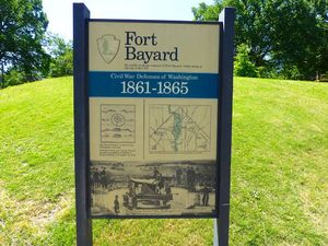
The Park Service, not the city, maintains the park in which the Stone sits, and they have placed a sign to provide context for what had been. Fort Bayard was named for Brigadier George Dashiell Bayard, who was killed in the Battle of Frederickburg, charging up Marye’s Heights, where stoic Union soldiers scrawled labels with their names to affix to their tunics, so when killed, the bodies could be returned to their kin. Later, the Army formalized the process with the metal oblongs we now call “dog tags.”

(Fort Bayard schematic courtesy National Park Service).
Fort Bayard never faced major opposition during the conflict and was decommissioned immediately following the surrender of the Army of Northern Virginia at Appomattox in 1865. Parts of the massive dirt and timber defenses remained, looming for years, and some can still be found, but here there is no trace. Only NW6 reminds us that once this was not a bustling residential area but brush and trees where a party of doughty surveyors hacked their way up to place the Stone.
NW6 is easy. The Stone itself is located in the park northeast of the intersection of Park and Western Avenues. It’s easy to find parking with a quick left turn onto Park.
I took the obligatory pictures to document the event, and headed back to the car. My confidence was being restored. I turned the Sebring around, took the left turn onto Western Avenue (Doh! That’s why they named it that!) and then motored off to the northwest as the avenue continued straight as a die, demarking precisely the jurisdictions of Maryland and the United States.
I was hoping the rest would be just as easy. Maybe I could knock them all out in an afternoon. As I drove, I pondered how I was going to nail NW4 and 5 for sure. Next time, for sure.
“Keep calm,” I said to myself. “And carry on.”
Copyright 2016 Vic Socotra
www.vicsocotra.com
Twitter: @jayare303
